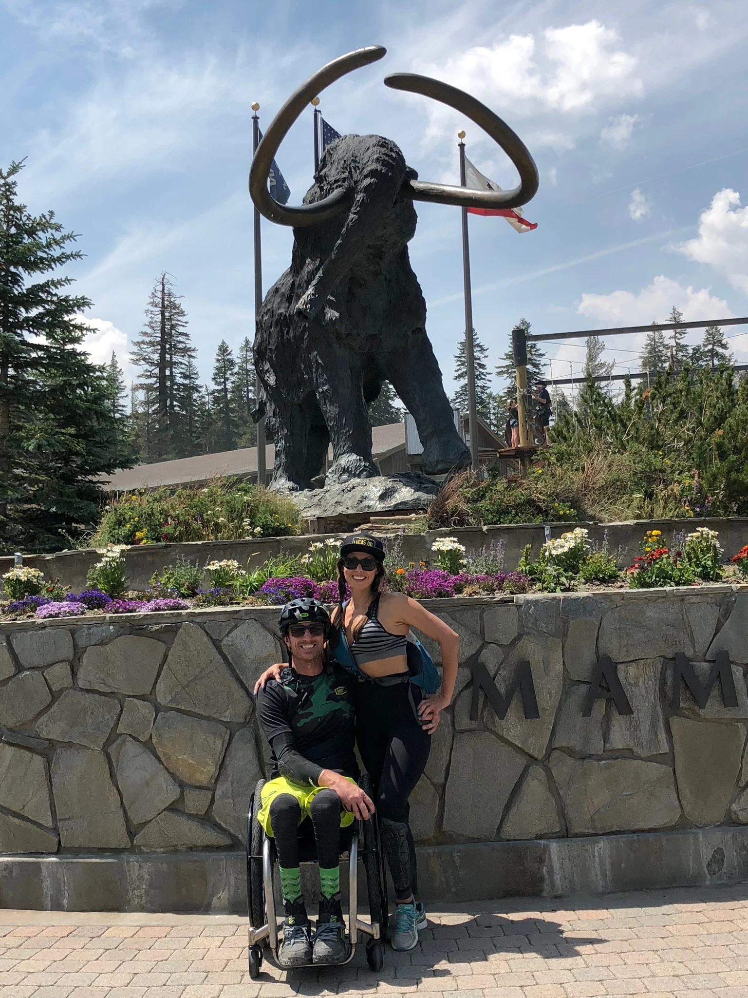
The Coast to Crest Trail
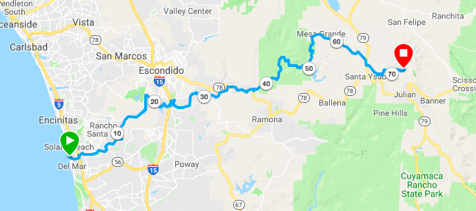
I have become obsessed with the Coast to Crest Trail in North County San Diego. It follows the San Dieguito River Park and spans over 70 miles from the beach in Delmar through Fairbanks Ranch to Lake Hodges and then east to Julian. When I first heard about it, I geeked out on Google satellite to all hours of the night, drove around like a trail creeper scoping trailheads and exploring trails section by section. I quickly realized, however, that the Coast to Crest only exists in segments and is not a trail that connects through at all. It would be amazing, but what I have discovered is that it would actually take an act of God to get it done. The City has plans, and it will be cool when those are complete in the far off future, but the plans call for a dirt path along a busy road in order to bypass a section of existing trail that passes though private land in Fairbanks Ranch. I went out there, on my own, and found all this out the hard way.
Section 1: Delmar
Super nice and maintained
Technically the trail starts off Jimmy Durante Road by the Delmar Fair Grounds. The trailhead is clearly marked with ample parking and the trail is very well maintained, but there is one big problem. No bikes allowed. What!!! Now my bike is considered by the FDA as an off-road wheelchair, specifically “an off-road three-wheeled carriage for person’s with disabilities.” That cracks me up. When i think of a carriage, i think of a fancy horse drawn wagon used by British aristocracy in the Colonial Era. The literal definition “a means of conveyance” actually works though. I guess my bike conveys me.
The next problem I discovered was a huge wash out making it impossible for me to get through and ending my ride for that day. I haven’t been out there since, but hoping its been repaired because some day, I plan on riding the whole thing and having apple pie in Julian at the finish. This will take having multiple batteries, a bike trailer, solar panels, a generator and most likely an overnight. Exciting!
The wash out
When the trail gets to the polo fields, technically it ends. There is trail there, but it is officially not a trail according to the San Dieguito River Park officials. Not sure what the plan is here. I’m assuming things will continue the way they are and what is an unmaintained infrequently ridden trail will stay as is.
Section 2: Fairbanks Ranch
This is the section of the Coast to Crest that exists already but is illegal because of private easements. I went out there and riding meant being a little sneaky. At the end of the golf course there is a chain across the trail and you are supposed to divert to San Dieguito Rd where the City plans on building a path. That totally sucks though. I had been scrupulously studying the trail from a satellite in space that took pictures of it (a.k.a. Google Maps) and the investigator in me just could not obey…so I ducked the line.
No one has been here for a long time
On the other side is nothing more than an old unmaintained fire road running along the creek between housing developments. Its ugly and it seemed like I was the only person to be there in months. No tracks. Overgrown. Nothing. An occasional dog barked at me from the neighborhood. I feared some old white rich conservative would yell at me from their manicured yard, but then i thought, “These people don’t go outside.” The only person who would see me would be a grounds keeper from a sit-on-top mower and why the heck would they care!
The area is ugly and it is sad to me that it is sitting there, protected by people who don’t want to share it. Just a little bit of work and what is an eyesore, if any eyes ever get to see it, could become something beautiful for a community to enjoy. Its existing trail! The City is planning on building NEW trail in order to bypass what is there already! Doesn’t make sense to me.
Existing trail that we can’t use
The trail then dead ends at a florescent green pond under a bridge at the edge someone’s private ranch. It looked like the trail maybe continued on the other side of the water, but i didn’t dare go through it. I imagined overgrown crawdads nipping my toes, contracting some weird infection or growing a third nipple. I turned around and rode home crestfallen. I kept running into dead ends.
Recently, I rode as far as I could from the other direction, east to west, again through private property, and actually got to the edge of that same private ranch on the other side. Two large weimaraners frolicked gangly with awkward paws in the rolling green grass. A pony sat dejectedly and lonely with what looked like a bag over its head, against a bright white fence. I was the stranger, an intruder. I tired to figure out where I was by looking on my phone, but couldn’t quite figure it out and I was scared someone would call the cops on me. The sun was also getting low and I had a ways to go to get back. It wasn’t til i got home and studied the map that i realized i was just on the other side of that ranch. It, realistically, would not take much physically to connect the trail, but to get those people to agree to it, that would take the act of God.
Section 3: Lusardi Creek & Lake Hodges
On the other side is Lusardi Creek Preserve. Lusardi is a fun area to ride, even if you are not connecting through to the “Coast to Crest”. There is a popular 9.3 mile loop that I like to do. The area connects, via easily accessible trail, to Los Peńasquitos to the south, Black Mountain to the east and Lake Hodges to the North. I did a big loop from PQ to Lusardi and back through Gonzalez Canyon once. Pretty cool to link up the different areas.

Watch my latest episode of Weekly Ride about Lusardi Creek
Connecting to Hodges from Lusardi means continuing from coast to crest. I’m assuming this section of trail had a big influence on inspiring the concept of the Coast to Crest Trail. Its well maintained, picturesque, unique and an absolute pleasure to ride. it takes you over cool bridges and has an intricate switch back section.
Riding along Lake Hodges is sweet too and then you cross under the 15 Freeway…
Section 4: Raptor Ridge

Raptor Ridge - One of my favorite trails i have ever ridden in San Diego
After crossing under the interstate, the trail is pretty boring and flat until it gets to Raptor Ridge, which is best ridden east to west, downhill. It is crazy fun and one of my favorite rides in all of San Diego County. The problem for me is a large rock cropping at the bottom, west side, that is a deal breaker for me. I got myself over this once, but it was not pretty and took about an hour. I thought about sending it off the rock on the right (see pic) and i probably could have pulled it off, but a newly found sense of self-preservation has come out of nowhere lately and my usual reckless abandon has fallen prey to it.
Rocks at the bottom of Raptor Ridge
On the other side of Raptor Ridge is some more unmaintained, overgrown fire road that leads back to the 78 near the Wild Animal Park and that is as much of the Coast to Crest as I have ridden. There is more to it, but it does not connect. From what i gather, some of it is not do-able for me until you get closer to Julian, where its mostly fire roads. In Julian, the apple pie flows like wine.
Some day soon, I will ride the rest. I think my days of exploring solo are over though. That whole wanting to live thing! I might even do an overnight with my Burley Nomad trailer and bike pack gear too! Eventually, the Coast to Crest Trail will connect all the way through and it will be fun working with the San Dieguito River Park to make sure it is all adaptive bike accessible. It probably will not incorporate what an act of God could make happen, but we can do our best to push for it be hopeful.

First episode EVER about Lake Hodges